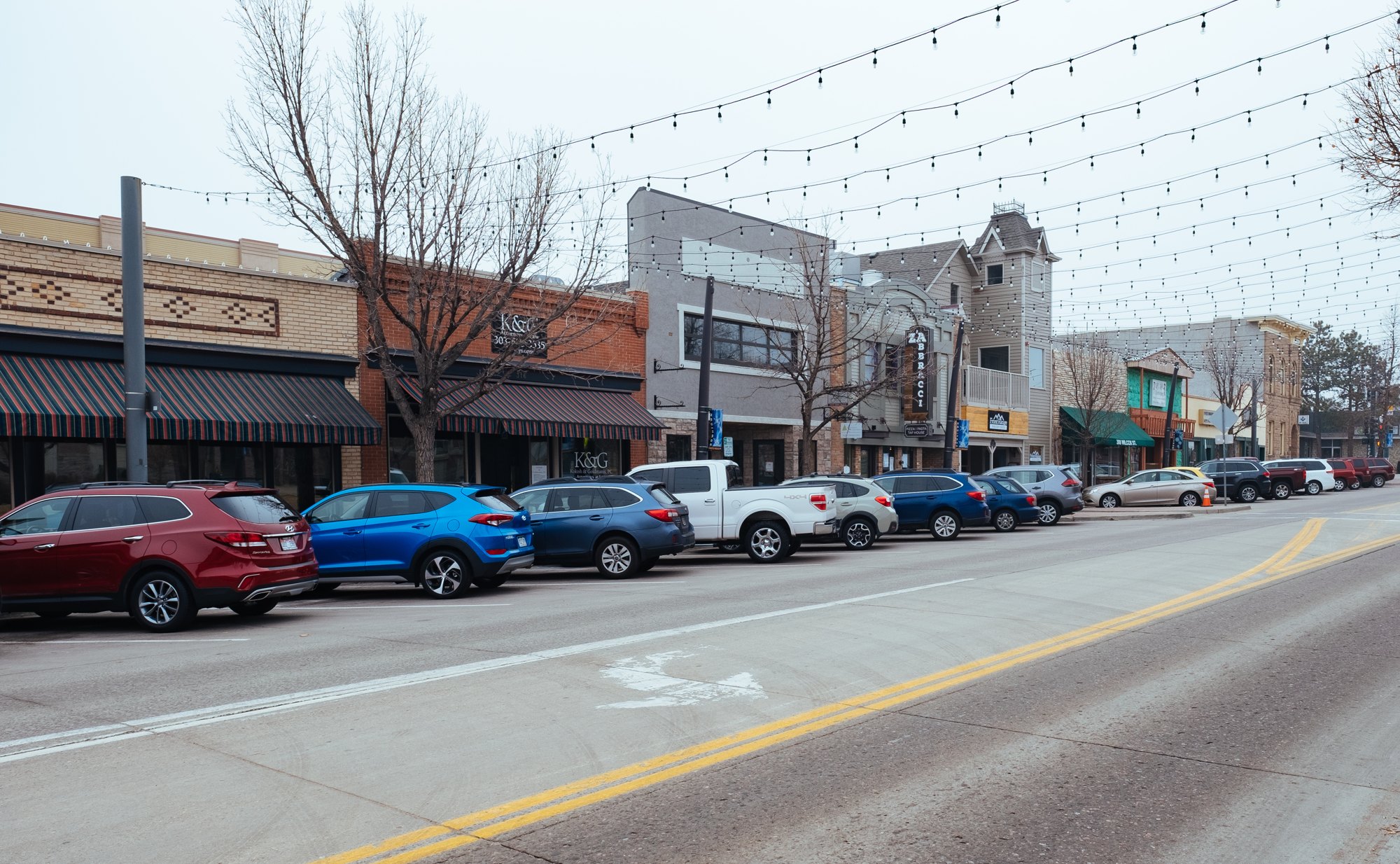
Wilcox Street in downtown Castle Rock (2018-02-09 09:37:29)

Outdoors

Camping near Castle Rock

Campgrounds and camping areas near Castle Rock on federal land, with which ones take reservations on Recreation.gov.

34campgrounds and camping areas
13 mito the closest
17within 30 miles
March–June, August–Novemberbest months

Good to know: Popular campgrounds book up months ahead on Recreation.gov; first-come sites fill early on weekends and holidays.

Closest picks

1

Rampart Range Recreation Area Designated Dispersed Camping

13 mi west · USDA Forest Service

The Rampart Range Recreation Area's Designated Dispersed Camping is operated by ExplorUS LLC. Camping is only allowed in numbered campsites and requires a fee. Trailhead parking within the Rampart Range Recreation Area is free.
2

Indian Creek Equestrian Campground

14 mi west · USDA Forest Service

Please Note: Must be in possession of a horse in order to camp in the equestrian campground. The Indian Creek Equestrian Campground is an ideal camping site for avid horseback riders looking to explore the Indian Creek Equestrian Trail.

3

Chatfield Lake

17 mi northwest · US Army Corps of Engineers

Chatfield Dam, located southwest of Denver on the South Platte River, was the second of three dams built to protect the Denver region from floods.

Map of all 34 places

Map of 34 places loads as you scroll.

Within 30 miles (17)

13 mi west · USDA Forest Service · Campground

Rampart Range Recreation Area Designated Dispersed Camping

The Rampart Range Recreation Area's Designated Dispersed Camping is operated by ExplorUS LLC. Camping is only allowed in numbered campsites and requires a fee. Trailhead parking within the Rampart Range Recreation Area is free.

  • Camping
  • Climbing
  • Lookout Tower
  • Off Highway Vehicle Trails
  • Picnicking

14 mi west · USDA Forest Service · Campground

Indian Creek Equestrian Campground

Please Note: Must be in possession of a horse in order to camp in the equestrian campground. The Indian Creek Equestrian Campground is an ideal camping site for avid horseback riders looking to explore the Indian Creek Equestrian Trail.

  • Camping
  • Fishing
  • Hiking
  • Horseback riding
  • Hunting

17 mi northwest · US Army Corps of Engineers

Chatfield Lake

Chatfield Dam, located southwest of Denver on the South Platte River, was the second of three dams built to protect the Denver region from floods.

  • Biking
  • Boating
  • Camping
  • Fishing
  • Hiking
  • Horseback riding
  • Picnicking
  • Water sports

19 mi north · US Army Corps of Engineers

Cherry Creek Lake

Cherry Creek Dam, located at the southeast edge of Denver in Aurora, CO, was the first of the three dams to be built to protect the Denver region from catastrophic South Platte River floodwaters that plagued the area for more than 100…

  • Boating
  • Camping
  • Fishing
  • Picnicking
  • Water sports
  • Wildlife viewing

22 mi southwest · USDA Forest Service · Campground

Lone Rock Campground (Co)

Lone Rock Campground, located along the South Platte River, boasts spectacular views and top-notch fly fishing waters. Hikers thoroughly enjoy the nearby Gill Trail and kayakers are drawn to the rapids of the rushing river.

  • Boating
  • Camping
  • Fishing
  • Hiking

23 mi west · USDA Forest Service · Campground

Kelsey Campground

Kelsey is one of two campgrounds within the Buffalo Creek Recreation Area, about an hour's drive southwest of Denver, Colorado.

  • Biking
  • Camping
  • Climbing
  • Hiking
  • Wildlife viewing

24 mi northwest · US Army Corps of Engineers

Bear Creek Lake

Bear Creek Dam, the last of three dams built to protect the Denver region from floods, is located on the southwest edge of suburban Lakewood at the confluence of Bear Creek and Turkey Creek.

  • Biking
  • Boating
  • Camping
  • Fishing
  • Hiking
  • Horseback riding
  • Hotel/Lodge/Resort Privately Owned
  • Picnicking

24 mi southwest · USDA Forest Service · Campground

Colorado Campground

Colorado Campground is a favorite family destination near Manitou Lake Picnic Area north of the town of Woodland Park. A short trail leads to the lovely lake, where visitors enjoy fishing, bird watching and canoeing.

  • Biking
  • Boating
  • Camping
  • Fishing
  • Hiking

24 mi southwest · USDA Forest Service · Campground

Manitou Lake Pavilion

Manitou Lake Picnic Area, is located 7 miles north of Woodland Park, Colorado,. The Manitou Lake Pavilion is located inside the picnic area and is a wonderful group day use picnic area for groups up to 50 people.

  • Biking
  • Boating
  • Camping
  • Fishing
  • Hiking

24 mi southwest · USDA Forest Service · Campground

Painted Rocks

Painted Rocks Campground is located a short distance from Manitou Lake Picnic Area and the Centennial Bike Trail in central Colorado.

  • Biking
  • Boating
  • Camping
  • Fishing
  • Hiking

25 mi west · USDA Forest Service · Campground

Meadows Group Campground

Meadows Group Campground offers a wonderful opportunity for groups to enjoy the great outdoors.

  • Biking
  • Camping
  • Fishing
  • Hiking

25 mi southwest · USDA Forest Service · Campground

Pike Community

Pike Community is a group campground located about 6 miles north of Woodland Park in central Colorado. It is a popular choice for of all ages, complete with a baseball field, sand volleyball court and a horseshoe pit.

  • Biking
  • Camping
  • Hiking

25 mi southwest · USDA Forest Service · Campground

South Meadows - Pike San Isabel NF (CO)

South Meadows Campground, located 5 miles north of Woodland Park, provides a scenic spot for campers to rest and enjoy the many recreational offerings of the area.

  • Camping

26 mi west · USDA Forest Service · Campground

Buffalo Campground

Buffalo Campground is one of two facilities within the Buffalo Creek Recreation Area, about an hour's drive southwest of Denver, Colorado.

  • Biking
  • Camping
  • Fishing
  • Hiking

26 mi southwest · USDA Forest Service · Campground

Red Rocks Group Campground

Red Rocks Group Campground is located 4 miles north of the town of Woodland Park, Colorado. Visitors enjoy the area for hiking, biking and visiting the nearby 5-acre Manitou Lake.

  • Biking
  • Camping
  • Hiking

28 mi south · USDA Forest Service · Campground

Meadow Ridge

Located about 10 miles from the town of Woodland Park, Colorado, Meadow Ridge Campground is pleasantly situated on a ridge above the Rampart Reservoir. Here, campers have access to prime fishing and mountain biking and hiking trails.

  • Biking
  • Camping
  • Fishing
  • Hiking

29 mi south · USDA Forest Service · Campground

Thunder Ridge

Thunder Ridge Campground, located above the Rampart Reservoir, is one of two campgrounds within the Rampart Reservoir Recreation Area. The campground overlooks the reservoir, which is popular for fishing.

  • Biking
  • Camping
  • Fishing
  • Hiking

30 to 75 miles (10)

37 mi southwest · USDA Forest Service · Campground

Spruce Grove Campground

The beautiful Spruce Grove campground is positioned beside large rock outcroppings on Tarryall Creek. Magnificent hiking trails to the Lost Creek Wilderness Area are just steps away from the Creek Bridge.

  • Biking
  • Camping
  • Climbing
  • Fishing
  • Hiking
  • Rock Climbing

39 mi southwest · USDA Forest Service · Campground

Round Mountain

Round Mountain is a small, rustic campground that sits just 6 miles from Lake George and Eleven Mile Canyon, 11 miles from the Florissant Fossil Beds National Monument and 15 miles to Eleven Mile Reservoir.

  • Camping
  • Climbing
  • Fishing
  • Hiking
  • Mountain Biking

56 mi south · Bureau of Land Management

Shelf Road Sites

Shelf Road is one of the most popular sport climbing areas in Colorado. It is located in south central Colorado, north of Canon City. Shelf Road follows the old stagecoach route to Cripple Creek.

  • Camping
  • Climbing

67 mi south · Bureau of Land Management

Gold Belt Tour Back Country Byway

The Gold Belt Tour Back Country Byway retraces the historic travel routes for the World’s Greatest Gold Camp, Cripple Creek. Travel on a historic, narrow-gauge railroad bed, an old stage road, and a county road on the Byway.

  • Biking
  • Camping
  • Climbing
  • Fishing
  • Hiking
  • Horseback riding
  • Hunting
  • Picnicking

68 mi northwest · Bureau of Land Management

Strawberry

The Strawberry area includes approximately 8 miles of Single-track, non- motorized trails that are collectively known as the Phases.

  • Biking
  • Camping
  • Hiking
  • Horseback riding
  • Hunting

70 mi north · Bureau of Reclamation

Carter Reservoir (Carter Lake)

Developments include 5 campgrounds with 151 campsites and 3 boat-launch ramps. A concession-operated public marina located at the north end of the lake (970.667.1062).

  • Biking
  • Boating
  • Camping
  • Fishing
  • Hiking
  • Nature education
  • Picnicking
  • Ranger programs

71 mi west · Bureau of Land Management

Mosquito Peaks

This beautiful high-alpine tundra and Area of Critical Environmental Concern contains significant biodiversity. There are several small parcels of BLM land here, with unique geological formations and 18 rare plant species.

  • Camping
  • Hiking
  • Off-highway vehicles
  • Wildlife viewing

72 mi north · Bureau of Reclamation

Flatiron Reservoir

Flatiron Dam and Reservoir are located on Chimney Hollow Creek 8 miles southwest of Loveland, Colorado. The dam and reservoir are features of the Colorado - Big Thompson Project . One campground with 41 campsites. Access is good.

  • Biking
  • Camping
  • Fishing
  • Hiking
  • Hunting
  • Nature education
  • Picnicking
  • Ranger programs

72 mi north · Bureau of Reclamation

Pinewood Lake

Pinewood Lake is located about 12 miles southwest of Loveland, Colorado. The Lake and Dam are a small part of the Colorado-Big Thompson Project , one of the largest and most complex ever constructed by Reclamation.

  • Boating
  • Camping
  • Fishing
  • Picnicking
  • Wildlife viewing

73 mi southwest · USDA Forest Service

Pike and San Isabel National Forests & Cimarron and Comanche National Grasslands

Peaks to Prairies - Tracks to Trails Pike and San Isabel National Forests & Cimarron and Comanche National Grasslands ( forest locator map ) cover nearly 3 million acres, between the prairies of western Kansas and some of Colorado's…

  • Biking
  • Boating
  • Camping
  • Climbing
  • Fire Lookouts/Cabins Overnight
  • Fishing
  • Hiking
  • Horse Camping

75 miles and farther (7)

76 mi northwest · Bureau of Reclamation

East Portal Reservoir

East Portal Reservoir is a feature of the Colorado - Big Thompson Project. This charming campground sits at the base of a mountain in the midst of a pine forest.

  • Camping
  • Fishing
  • Hiking
  • Picnicking
  • Recreational Vehicles
  • Wildlife viewing

76 mi northwest · Bureau of Reclamation

Marys Lake

Marys Lake is part of the Colorado-Big Thompson Project. There are 2 dikes on the shoreline of Marys Lake, located approximately 2 miles from Estes Park, Colorado.

  • Camping
  • Fishing
  • Picnicking
  • Recreational Vehicles
  • Water sports
  • Wildlife viewing

77 mi northwest · Bureau of Reclamation

Lake Granby

Granby Dam and Lake Granby, features of the Colorado-Big Thompson Project are on the Colorado River near Granby, Colorado. Developments include 260 campsites and 3 boat-launch ramps.

  • Biking
  • Boating
  • Camping
  • Fishing
  • Hiking
  • Picnicking
  • Recreational Vehicles
  • Wildlife viewing

77 mi southwest · Bureau of Land Management

Texas Creek

The Texas Creek Recreation area is located west of Canon City and is a popular high-use area for motorized recreation users.

  • Camping
  • Hunting
  • Off-highway vehicles

78 mi south · Bureau of Reclamation

Pueblo Reservoir

Recreation at Pueblo Reservoir is managed by the Colorado State Parks under agreement with the Bureau of Reclamation, Eastern Colorado Area Office, Loveland, Colorado.Pueblo Reservoir was created by Pueblo Dam which crosses the Arkansas…

  • Biking
  • Boating
  • Camping
  • Fish Hatchery
  • Fishing
  • Hiking
  • Hunting
  • Picnicking

79 mi northwest · Bureau of Reclamation

Shadow Mountain Lake

Shadow Mountain Dam and Reservoir, Colorado-Big Thompson Project , are on the Colorado River below its confluence with the Grand Lake outlet. Developments include 1 campground with 80 campsites and 2 boat-launch ramps. Good access exists.

  • Boating
  • Camping
  • Fishing
  • Hiking
  • Picnicking
  • Recreational Vehicles
  • Water sports

79 mi northwest · Bureau of Reclamation

Willow Creek Reservoir

Willow Creek, a tributary on the Colorado River near Granby, Colorado, is diverted by Willow Creek Dam and Canal, features of the Colorado-Big Thompson Project.

  • Boating
  • Camping
  • Fishing
  • Hunting
  • Picnicking
  • Recreational Vehicles
  • Water sports

Distances are straight-line miles from downtown Castle Rock. Listings come from Recreation.gov’s federal recreation database; check each official page for hours, fees, fire restrictions and closures before you go.

Get outside around Castle Rock

Hiking up to the Rock video thumbnail

THINGS TO DO · YOUTUBE SHORT

Hiking up to the Rock

The short climb in Rock Park toward the butte that gives the town its name, with views over downtown. A Short shared by Espi Agency | Colorado Real Estate.

Watch on YouTube ↗
Challenge Hill at Philip S. Miller Park video thumbnail

THINGS TO DO · YOUTUBE SHORT

Challenge Hill at Philip S. Miller Park

Climbing Challenge Hill, the steep staircase nicknamed the miniature incline, at Philip S. Miller Park. A Short shared by DadandAshton.

Watch on YouTube ↗

More outdoors near Castle Rock

Questions

Where is the closest place for camping near Castle Rock?

Rampart Range Recreation Area Designated Dispersed Camping (USDA Forest Service), about 13 miles west of Castle Rock as the crow flies. Next are Indian Creek Equestrian Campground (14 mi) and Chatfield Lake (17 mi).

When is the best time for camping near Castle Rock?

Based on Castle Rock’s average highs, March–June, August–November. Conditions at higher elevations can be much cooler.

Can I reserve a campsite near Castle Rock?

16 of the 34 places listed here take reservations on Recreation.gov; others are first come, first served.

Who manages these places?

Federal agencies including USDA Forest Service, Bureau of Reclamation, Bureau of Land Management. Each listing links to its official page for hours, fees, closures and current conditions.

Castle Rock AI

Your Castle Rock local guide
Hey there!

I'm Castle Rock AI. Ask about neighborhood food, independent shops, local history or planning a visit.

AI recommendations may be inaccurate. Verify hours and prices. Questions are processed by Cloudflare. Privacy